Cycling in Gloucestershire
The Welsh Borders, or Marches, part of Gloucestershire could loosely be described as lying between the River Severn to the east and Wales to the west, so that is what we are covering here.
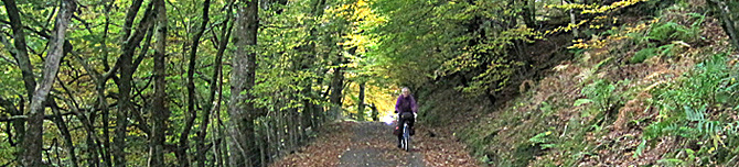
The Forest of Dean
 The
Royal Forest of Dean (to give it its full name) is one of the best
old forests in England, comprising some 42 square miles of mixed
woodland sitting between the rivers Severn and Wye, to the south of
Ross-on-Wye.
The
Royal Forest of Dean (to give it its full name) is one of the best
old forests in England, comprising some 42 square miles of mixed
woodland sitting between the rivers Severn and Wye, to the south of
Ross-on-Wye.
Today we see it as a tourist pleasure land, but in the past it was a hive of industry. Due to huge iron ore reserves and abundance of timber, the forest was an important area of iron production for hundreds of years.
The idea of the 'picturesque' began here. During the Napoleonic Wars the rich could no longer take their Grand Tour on the continent, so they came here instead. William Gilpin wrote about boats full of rich tourists floating down river from Ross-on-Wye, calling at Goodrich Castle for a tipple, and ending at Symond's Yat where the gentry could admire sweaty working-class men stripped to the waist toiling in the blast furnaces that lined the east bank of River Wye. The whole valley glowed red with fire.
One of our favourite rides takes in the lane from Staunton to
Newland for lunch at The Ostrich Inn. Newland's huge church is known
as the 'Cathedral of the Forest' containing the 'Miners
Brass' depicting a mediaeval Freeminer with a candlestick in
his mouth - miners had to provide their own lighting, possibly
whilst hewing coal lying on their sides! Free Mining is unique to
the Forest of Dean - to become a Freeminer you have to be born and
live within the Hundred of St Briavels.
If you're into some big climbs, try the lane up from Upper Lydbrook, via Joy's Green, to The Pludds - it keeps going up and up and up around every bend!
For a 5 mile traffic-free cycle/walking route, see The Wye Valley Greenway along an old railway track following the River Wye from Chepstow to Tintern.
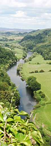
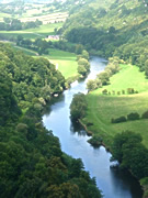
Symond's Yat

Photo: Symonds Yat by Royal Forest of Dean Info
Symond's Yat, in the Forest of Dean, is divided by the River Wye into Symond's Yat East and Symond's Yat West, connected by two passenger ferries (run by The Saracens Head and Ye Old Ferrie Inn), a footbridge (very narrow, with steps either side) about 1 mile downriver at The Biblins, and the road bridge about a mile to the north.
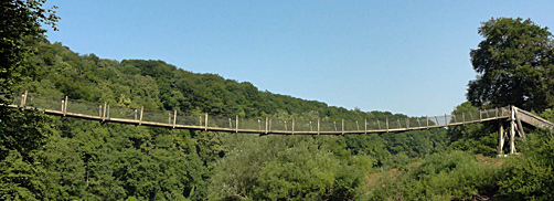
Photo: Bibblins footbridge over River Wye at Symonds Yat
Symond's Yat may (or may not) have got its name from a route used by seamen travelling from further north through the steep-sided gorge on their way to the coast. 'Yat' meaning 'gate', so Symond's Yat would be the Seamens' Gateway.
This is the busiest tourist spot for miles around, but still worth visiting if you can choose a quiet day avoiding summer weekends.
Kempley's Old Church
The now redundant small church of St Mary's, Kempley is a real gem and well worth a visit. This Norman church has some of best preserved medieval wall paintings in Britain. The ones on the barrelled ceiling of the chancel are particularly rare (c. 1130), and are the most complete set of Romanesque frescoes in northern Europe.
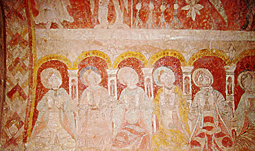
Photo: ceiling painting of The Apostles in chancel

Photo: window in chancel of Kempley old church
The church also has the oldest timber roof in England (dating from 1120-1150), as well a rather fine timber-frame porch and Norman doorway arch.
Location: St Mary's is about one mile north of the village of Kempley (not the newer church in Kempley itself, which is also rather interesting in an Arts and Crafts sort of way).
The Dymock Poets
The Dymock Poets, famous for their anti-war poems, lived around the village of Dymock between 1911 and the out-break of war in 1914. The group comprised Robert Frost, Rupert Brooke, Lascelles Abercrombie, Edward Thomas, Wilfrid Wilson Gibson, and John Drinkwater. A small exhibition of their poems is in Dymock church. Here is a cycling poem by Abercrombie displayed in the church...

An aside: on Bicycle Beano the definition of 'a Dymock' was a cyclist who frantically searched for something in both pannier bags and bar bag 2 or 3 times, only to find it later in their pocket!
May Hill
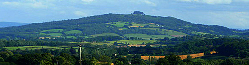
May Hill can be recognized from miles away because of its distinctive rounded shape with a clump of trees on top. The highest point around here, at 969 feet (275 metres), you can see 12 other counties from the top on a clear day.
A little challenge for hill climbers is to cycle up the lane over the northern end of the hill from west to east. The lane along the western side of the hill and over the southern end is less challenging and takes you to The Glass House Inn.
The Bee Shelter
There is an amazing restored bee shelter in the back of Hartpury churchyard.
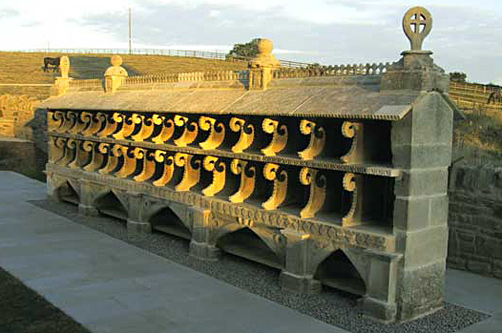
Photo credit: Hartpury Heritage Trust
Measuring 24 feet long by 14 feet high, this unique structure could accommodate about 840,000 bees in 28 'skeps' (coiled straw or wicker baskets placed open-end-down). Before beekeepers started using the modern hive, they kept their bees in 'skeps'. The honey was harvested by burning the skep. Full details are on a display board.
Location: near Highleadon on lane west from Hartpury village; map ref: SO 780 236.
There is a lovely Tithe Barn opposite Hartpury church, but it is private. However the National Trust's 15th century Tithe Barn at Ashleworth is open every day - just a couple of miles to the east (map ref: SO 817 252). And then you can take lunch at the wonderful Boat Inn on the west bank of the River Severn.
Cycling Maps
 Forest
of Dean and Wye Valley Cycling Guide
Forest
of Dean and Wye Valley Cycling Guide
 Herefordshire,
Worcestershire & North Gloucestershire Cycle Map - shows
on-road and traffic-free cycle paths, height contours, town centre
maps, recommended linking routes connecting the National Cycling
Network with quiet roads. Published by Sustrans. 1:110,000 scale.
About £6.
Herefordshire,
Worcestershire & North Gloucestershire Cycle Map - shows
on-road and traffic-free cycle paths, height contours, town centre
maps, recommended linking routes connecting the National Cycling
Network with quiet roads. Published by Sustrans. 1:110,000 scale.
About £6.
Or buy the ordinary Ordnance Survey Landranger map Number 162 "Gloucester & Forest of Dean" from Amazon.co.uk; scale 1:50 000 (1.25 in to 1 mile), about £7-9.
We take no responsibility and give no guarantees or warranties, implied or otherwise, for the content or accuracy of any linked sites above.